 1 week Ago
Charleston began a process years ago to rewrite its zoning code with a fresh appreciation that many parts of the city face an increasing risk of floods while other parts are more suitable places to build in the long run. North Charleston now faces a similar opportunity, not so much to respond to flooding realities — though they certainly exist to some extent — but to shape a zoning code around the new opportunities presented by the emerging bus rapid transit line that will run along its entire length, from Ladson to the Charleston city line. Charleston's rezoning rewrite is now on pause, as Mayor William Cogswell's staff works to assemble a new series of maps incorporating existing zoning, development, road capacity, drainage issues and more.
We hope it will resume soon. Meanwhile, North Charleston's is just beginning. Or beginning to begin.

Last week, the city started soliciting planning, zoning and legal consultants interested in helping create a new unified development ordinance that will consolidate and modernize its zoning and subdivision regulations. The goal of the update is to help eliminate obstacles to more housing construction and integrate form-based code principles, design guidelines and transit-oriented zoning. The latter piece will not start from scratch.
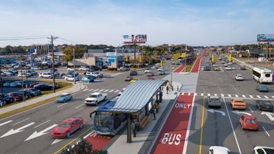
As the Charleston Area Regional Transportation Authority began planning South Carolina's first mass transit system, the Berkeley-Charleston-Dorchester Council of Governments got a federal grant to do some initial transit-oriented planning in recognition that the new bus line — the first with features to help its buses travel faster than nearby vehicular traffic — could change the game. The rewrite is one of the first big moves by North Charleston Mayor Reggie Burgess, who tells us the unified development ordinance will shape how North Charleston grows for decades to come. "So we’re committed to doing it right," he said.
"Our goal is to create a modern, inclusive framework that promotes housing, protects neighborhoods and drives economic opportunity. ..
. This is one of the most important planning efforts in our city’s history, and we intend to get it right.” Getting it right will involve more than recognizing how bus rapid transit will change the city.
North Charleston's version should share some of the same objectives laid out in Charleston's effort: creating a zoning framework that is easier for the public to understand and follow, recognizing resiliency realities, particularly increased flooding in the lowest lying areas, and ensuring that development rules are sensitive to the context in different parts of the city. Just as Charleston's Harleston Village differs from Daniel Island, which differs from Cross Creek on James Island, North Charleston's variety runs the gamut from the small, intimate streets of Union Heights to the expansive homes behind the gates at Coosaw Creek. An effective rezoning rewrite should respect these differences and guide new development and redevelopment in a way that complements rather than competes with the neighbors.
Just as Charleston's zoning code hasn't seen a major update in more than half a century, the zoning regulations in North Charleston have mostly built up over time, like barnacles on a boat's hull, since the city was formed in 1972. It will be months before North Charleston City Council is presented with an opportunity to approve a contract for a consulting team to work on a new development ordinance, and it likely will be more months still before the team gears up work and begins to engage the public. That might seem like a ways away, but it's not too early for North Charleston's city officials, businesses, property owners, neighborhood leaders and residents to start thinking about what they would like their city to look like as it continues to grow up.
Click here for more opinion content from The Post and Courier..