 3 weeks Ago
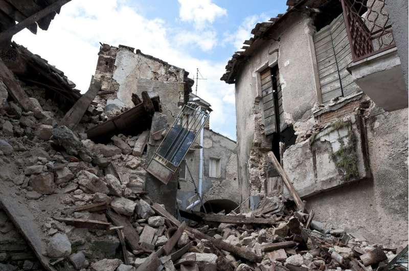
April 15, 2025 This article has been reviewed according to Science X's editorial process and policies . Editors have highlightedthe following attributes while ensuring the content's credibility: fact-checked trusted source proofread by Seismological Society of America The 28 March magnitude 7.7 Mandalay, Burma (Myanmar) earthquake caused widespread and severe damage in Myanmar and neighboring countries such as Thailand, with more than 5,000 casualties now confirmed.
At the Seismological Society of America's Annual Meeting , researchers from around the globe shared early insights into the earthquake's fault properties, ground shaking and infrastructure damage. Understanding the rupture Myanmar is located in a region of complex collisions between the India and Eurasia tectonic plates . The March earthquake ruptured more than 400 kilometers of the Sagaing fault , which is the main lateral plate boundary fault in the country and runs through central Myanmar, said U.

S. Geological Survey seismologist Susan Hough. This is one of the largest surface ruptures observed globally, according to USGS researcher Nadine Reitman.
The Sagaing fault has a history of large, magnitude 6+ earthquakes within the past 100 years, although the March earthquake took place in a region that had not experienced a magnitude 7 earthquake since 1839, Reitman reported. The rupture went "supershear"—rupturing faster than the speed of sound—after an initial slow start, as would be expected for a large strike-slip earthquake, said Zhigang Peng of Georgia Institute of Technology. Peng noted that earthquake catalogs in Thailand and Yunnan and Guangdong provinces in China have shown a significant increase in seismic activity after the earthquake, suggesting widespread triggering by dynamic stresses from the Myanmar mainshock.
Severe ground shaking The earthquake caused damaging shaking that extended more than 100 kilometers away from the fault in Mandalay, Sagaing, Nay Pyi Taw, Bago and Shan State, among other locations, Hough said. She noted that the Department of Meteorology and Hydrology in Nay Pyi Taw, which operates Myanmar's national seismic network, was severely impacted by the shaking. Shake maps from the earthquake analyzed by Chung-Han Chan of the National Central University in Taiwan indicate that regions intersected by the rupture probably experienced Modified Mercalli Intensity values exceeding VIII, where shaking causes difficulty standing, can move heavy furniture and cause damage to structures that are not earthquake-resistant.
Hiroshi Kawase of General Building Research Corporation of Japan and colleagues presented their research on local site conditions, which they have been conducting since 2014, to help estimate ground motion in the cities of Sagaing and Yangon along the Sagaing fault. Data from sky and sea Satellite imagery allowed Xuechun Li of Johns Hopkins University and colleagues to develop a comprehensive city-scale map of earthquake effects in Mandalay within days, suggesting their technique could be useful in rapid post-disaster damage assessments. The Myanmar earthquake also marks the first time a large-magnitude earthquake has been detected using an array of telecommunication submarine cable networks turned into more than 100 seismic sensors, reported Mikael Mazur of Nokia Bell Labs at the SSA meeting.
Provided by Seismological Society of America.